
How To Play The Game
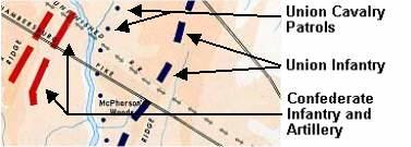
This simulation is based on historical maps that show the position of Confederate and Union forces during the battle. The maps and their style are based on the West Point Atlas series used to train military cadets for centuries at the United States Military Academy (West Point).
Opposing military forces are shown as different colored lines or dots. The longer or thicker the line, the more troops they represent. In this case, Red lines indicate Confederate (Southern) troops and Blue lines represent Union (Northern) troops.
Straight lines, like those at left and below, indicate infantry and artillery forces. Dots represent cavalry patrols (in this case, Union cavalry since they are blue in color). These usually represent lightly guarded flanks of an army or forward scouts.
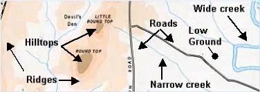
The different colors on the map indicate higher or lower elevations White represents the lowest ground, while dark brown indicates the peaks of small hills. Ridges and hills are usually easier to defend and harder to attack. The blue lines represent creeks. The wider the blue area is, the wider the creek and the more difficult it is to cross. Roads are indicated by black lines and are important to keep open in order to receive supplies and reinforcements.
With this basic primer, you should be ready to get into the saddle and assume command of the Army of Northern Virginia!


")

")
")
")
")


")